Canadian National Geothermal Database & territory Resource Estimate Maps:
|
The Nunavut Geothermal Feasibility study is the first phase in identifying potential geothermal resources to help offset the use of diesel for electricity & heat in the isolated communities of Nunavut. The objectives of this study were to gather existing data, identify data gaps, and conduct a geothermal resource assessment based on the existing data. The framework, methodology, and deliverables of the assessment are designed around the reporting guidelines that were set by the Canadian Geothermal Energy Association (CanGEA) for the Canadian National Geothermal Database (CNGD) [Canadian Geothermal Code Committee, 2010].
Key findings from report:
- The geothermal potential of Nunavut is generally considered to be low compared to other provinces and territories. This is partially driven by the absence of data necessary to characterize the resource potential in Nunavut.
- Any geothermal development would need to occur at or near the isolated communities as there is no infrastructure to support energy transfer and resource temperatures will not support large scale power production.
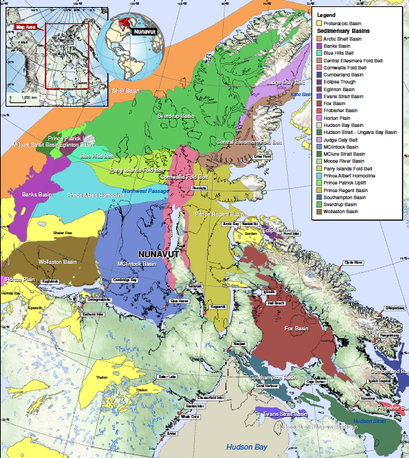
- The territory is divided into two major geological regions and the geothermal resource is defined by those regions. The Arctic Basins region in the northwestern area of Nunavut is a sedimentary geothermal resource and has been preliminary characterized by oil and gas exploration.
- The Canadian Shield region will require a Enhanced Geothermal System (EGS) at depths of 5 km – 7km to reach temperatures suitable for binary power generation and direct use heating.
- The general Global Protocol methodology was used for this study with some modifications due to the absence of data. Theoretical and technical potential was calculated across the entire Territory of Nunavut regardless of data availability. Due to lack of data, values were estimated based on rock type, which included the entirety of the Canadian Shield region
- Under the Canadian Code for Public Reporting, generated resource maps are considered to have low confidence. No areas were considered to meet the minimum resource category of an inferred resource.
- Additional data collection is a key next step needed to properly define geothermal resource potential in Nunavut. It is recommended that Nunavut prioritize the drilling small diameter geothermal gradient wells at target communities to depths below the permafrost to measure subsurface thermal properties.
- Potential application of hybrid solar thermal – binary geothermal power production may be cost effective and increase overall power production. A thick permafrost, >500 meters, is a challenging heat sink that can be overcome with unique well bore designs. Enhanced Geothermal Systems are being developed around the world but economic and sustainability challenges remain.
.kmz Maps - Google Earth interactive map
Check out this interactive .kmz map (Google Earth viewable file) illustrating the results from the Nunavut geothermal feasibility study. The map below shows the geothermal favourability map for Nunavut. Make sure to download a copy of Google if you do not already have it and open the file with Google Earth.
The Google Earth program is required to view the .kml maps that can be found below.
Click here to download a free copy of Google Earth
Click here to download a free copy of Google Earth
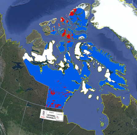
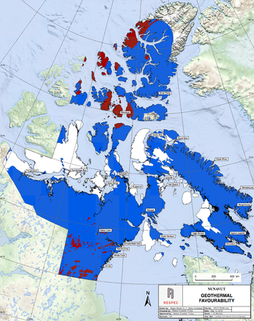
Snapshot from .kmz Map of the Geothermal Favourability Map
Nunavut Geothermal Favourability
Arctic Basin Geothermal Gradient
Arctic Basin Geothermal Heat Flow
Arctic Basin GEOTHERMAL conductivity
Arctic Basin temperature at various depths
Canadian shield geothermal heat flow
Canadian shield Temperature at various depths
Nunavut Geothermal Favourability Maps
The Nunavut Favourability Map project has included an estimate of Theoretical and Technical Potential as detailed by the methodology in the Global Protocol for Estimating and Mapping Geothermal Potential.
Below the following graphs and tables you will find further information and descriptions concerning the classification of Inferred and Indicated Resources.
*It should be noted that all of the stated values are approximate and are only relevant to the data available and thus do not fully represent the entire geothermal potential of Nunavut.
|
Technical Potential: “the fraction of the theoretical potential that can be used under the existing technical restrictions… structural and ecologic restrictions as well as legal and regulatory allowances.” (Rybach, 2010)
|
Theoretical Potential: an estimate of “the physically usable energy supply over a certain time span in a given region. It is defined solely by the physical limits of use and thus marks the upper limit of the theoretically realizable energy supply contribution.” (Rybach, 2010)
|
PDf Maps Generated from Study:

Canadian Shield and Heat Flow
Below you will find some of the PDF maps generated from this study !
Main PDF Maps generated from Nunavut Geothermal Feasibility Study
Arctic Basin Estimated Technical potential maps
Arctic basin theoretical potential maps
Arctic basin rasters maps
Arctic basin temperatures at various depths
Canadian shield estimated technical potential heat flow median
Canadian shield Estimated theoretical potential median
Canadian Shield median temperature heat flow
Nunavut Geothermal Database (.gdp file)
Distinct from other geothermal resource maps developed in Canada, the maps follow international guidelines already adopted in the U.S., Australia, South Korea, Spain, and Europe and have been adapted for compliance with the
Presented to the public in a universal mapping platform and centralized national geothermal database, the project deliverables also provide a means to share, collaborate or update data necessary for making informed business decisions.