Canadian National Geothermal Database and Territorial Resource Estimate Maps:
| ||||||||||||||||
|
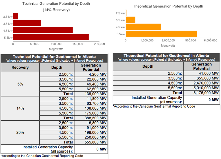
Technical Potential: “the fraction of the theoretical potential that can be used under the existing technical restrictions… structural and ecologic restrictions as well as legal and regulatory allowances” (Rybach, 2010).
|
Theoretical Potential: an estimate of “the physically usable energy supply over a certain time span in a given region. It is defined solely by the physical limits of use and thus marks the upper limit of the theoretically realizable energy supply contribution” (Rybach, 2010).
|
Google Earth Maps
The Google Earth program is required to view the following maps. Click here to download a copy of Google Earth.
|
Temperature at Depth Maps:
- Alberta Data Summary - Deep Systems: 1,000m – 6,000m - Shallow Systems (Direct Use): 100m – 500m Theoretical Potential Maps: - Alberta Data Summary - Theoretical Potential from 3,000-6,000m depth - Reporting Code (Indicated Resources) Supplemental Maps: - Alberta Data Summary - Annual Average Ambient Air Temperature at Surface - Temperature at Basement - Heat Flow Maps (at Surface and at Basement) - Temperature Gradient Maps from 1,000-6,000m depth - Conductivity Maps from 1,000-6,000m depth - Heat Generation Maps from 1,000-6,000m depth |
Technical Potential Maps:
- Alberta Data Summary - Technical Potential for Low (5%), Medium (14%) and High (20%) Recovery from 2,000-6,000m depth - Reporting Code (Indicated Resources) Favourability Map: - Alberta Data Summary - Alberta Subsurface Favourability Score - Land Use Layers Regional Analysis: - Alberta Data Summary - Regional Data Summaries |
Can't Use Google Earth? Download a PDF Version of the Maps
Methods and Data Sources
| Geothermal Favourability Map of Alberta Following a Global Protocol - Methods and Data Sources |
* Please note that the Methods & Data Sources report is not a summary of the analysis of the data, but is rather a summary of the methodology used to produce the Alberta Favourability Maps.
Following the Canadian Geothermal Code for Public Reporting, the Reporting Code maps represent the level of confidence that has been assigned to the data found within each grid block. This was done by analyzing the data points according to the Reporting Code and subsequently classifying each block as an Inferred or an Indicated Resource, suggesting a lower or higher level of confidence, respectively.
A Geothermal Resource is a geothermal play that exists in a form, quality and quantity that there are reasonable prospects of eventual economic extraction. The location, quantity, temperature, geological characteristics and extent of the Geothermal Resource are known, estimated or interpreted from specific geological knowledge and evidence. Geothermal Resources are subdivided in order of increasing confidence into:
- Inferred Resources
- Indicated Resources
- Measured Resources
The Inferred category is intended to cover situations where a Geothermal Play has been identified and limited measurements and sampling completed, but where the data are insufficient to allow the extent of the Geothermal Resource to be confidently interpreted. It is based mainly on indirect measurements, such as the extrapolation of temperature profiles (to a reasonable degree and on a rational basis) and other associated measurements such as rock properties and heat flow, and requires a reasonably sound understanding of the subsurface geology in three dimensions derived, for example, from geophysical surveys, to indicate temperature and dimensions
|
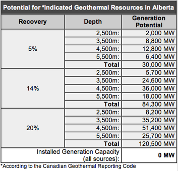
An ‘Indicated Geothermal Resource’ is that part of a geothermal resource that has been demonstrated to exist through direct measurements that indicate temperature and dimensions so that recoverable thermal energy (MWth-years) can be estimated with a reasonable level of confidence. Thermal energy in place has been estimated through direct measurements and assessments of volumes of hot rock and fluid with sufficient indicators to characterize the temperature and chemistry. Direct measurements are sufficiently spaced so as to indicate the extent of the thermal energy in place.
The Reporting Code was prepared by the Canadian Geothermal Code Committee and published in 2010. It is a required minimum standard for public reporting. If you would like to obtain a copy of the Code, please visit the “Code." |
|
Alberta Geothermal Database
Below you’ll find the database used for the generation of the Alberta Favourability Maps.

Alberta Database - for personal/private use
The database used for the Alberta Geothermal Favourability Maps is available for purchase. The download includes both .xls and .csv formats. The database includes for each grid blog (800 in total):
1) Average ambient air temperature
2) Temperature at depths 1500m, 2500m, 3500m, 4500m, 5500m
3) Sediment Thickness
1) Average ambient air temperature
2) Temperature at depths 1500m, 2500m, 3500m, 4500m, 5500m
3) Sediment Thickness
|
Biography of Geothermal Resource Assessment Lead, Qualified Person
|
Biography of Peer Reviewer, Qualified Person
| ||||
Supported By:
Distinct from other geothermal resource maps developed in Canada, the maps follow international guidelines already adopted in the U.S., Australia, South Korea, Spain, and Europe and have been adapted for compliance with the
Presented to the public in a universal mapping platform and centralized national geothermal database, the project deliverables also provide a means to share, collaborate or update data necessary for making informed business decisions.